(2: 河海大学, 水文水资源与水利工程科学国家重点实验室, 南京 210098)
(3: 长江水利委员会水文局, 武汉 430010)
(2: State Key Laboratory of Hydrology-Water Resources and Hydraulic Engineering, Hohai University, Nanjing 210098, P. R. China)
(3: Hydrology Bureau of Changjiang Water Resources Commission, Wuhan 430010, P. R. China)
近几十年来,极端自然条件和人类活动严重影响了河床变形[1]. 人类活动导致的扰动往往会迅速加速或改变自然过程和趋势,使得河道调整的时间尺度缩短[2]. 河流筑坝改变了原有的水沙输移过程,坝下游河道出现冲刷、水位调整等变化,来适应流量变化及沙量减少等影响[3-5]. 随着水库运行的时间推移,坝下游河道形态调整存在时空差异性[6],如长江[3-5]、黄河[7]、密西西比河[8]、密苏里河[9]、巴拉那河[10]等.
三峡工程是全球最大的综合性水利枢纽工程,具有防洪、发电、航运、供水和节能减排等巨大的综合效益[11],其运行对水沙通量、河床变形、生态环境等影响一直备受研究人员关注. 三峡水库运行采用“削峰补枯”的调度方式[11-12],调节了年内径流过程[13-14],径流总量影响较小,但下游输沙量大幅减少[15-16]. 三峡工程运行后,荆江河段已出现河槽冲刷及深泓下切,且冲刷集中在枯水河槽[17-19],部分河段横向展宽明显[20-21],由于岸线防护工程的实施,崩岸长度低于蓄水前[22]. 河床组成不同,使得河道形态调整存在时空差异[23]. 三峡大坝下游近坝段砂卵石段(昌门溪-大埠街),河床形态调整存在突变现象[24],沙质河段冲刷集中在枯水位以下[17, 25]. 一般而言,河道冲刷为航道水深的提高创造了有利条件[26],同时,长江中游河道冲刷未使得同流量-洪水位表现出下降趋势[3, 26],其防洪情势依然严峻. 三峡工程运行后,改变了特征流量在汊道间的摆动及持续时间,汊道冲刷发展速度不均衡,部分汊道出现了交替现象[27-29];急弯河段的演变特征主要表现为“凸岸边滩冲刷,凹岸侧深槽淤积”[30-31]. 截至2020年,三峡工程蓄水运行已有17年,不同蓄水期对坝下游河道演变的影响程度存在时空差异. 上述研究中,重点分析了长江中游的整体冲刷强度及滩槽分布等差异性特征,同时关注了汊道分流关系、边心滩形态、水位调整等方面. 但是,伴随三峡工程运行影响程度的加深、长江中游阶段性航道整治工程等实施,需深入探讨长江中游河床冲淤的时空差异性,明确分汊河段分流比及江心洲面积、弯曲段滩槽演变等特征对三峡工程及航道整治整治工程的响应关系.
本研究收集了1975—2017年实测地形数据,采用地形法计算长江中游(宜昌至湖口段)河段的河槽容积,研究河道冲淤、深泓、滩槽冲淤分布等参数变化,明确分汊河段分流比及江心洲面积、弯曲段滩槽演变等特征对三峡工程及航道整治整治工程的响应关系.
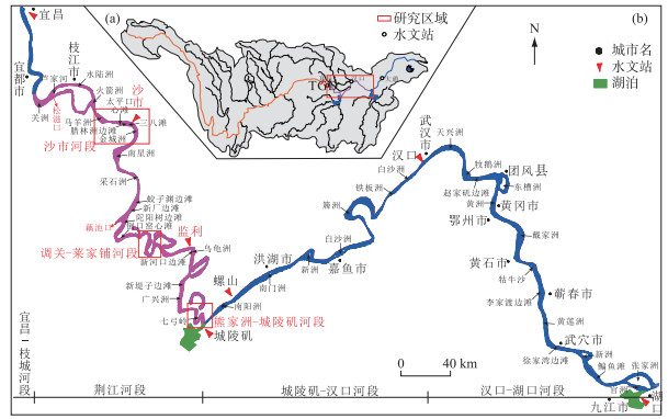
1 研究河段概况 1.1 研究区域长江干流河道总长度约为6397 km,其中宜昌以上为上游(4504 km),宜昌-湖口为中游(955 km),湖口以下为下游(938 km). 其中枝城-藕池口段为上荆江,藕池口-城陵矶段为下荆江(图 1). 宜昌至大埠街河段为砂卵石和砂卵石-沙质过渡河床(长约116.4 km),大埠街以下为沙质河床(长约1776.6 km)[5]. 洞庭湖和鄱阳湖位于长江南岸,由松滋口、太平口和藕池口分流进入洞庭湖,洞庭湖和鄱阳湖分别在城陵矶和湖口汇入长江. 长江中下游干流自上至下分布有宜昌、枝城、沙市、监利、螺山、汉口、大通等水文站. 汉江位于长江北岸,在武汉市入汇至长江干流.
|
图 1 长江流域(a)及研究区域(b)概况 Fig.1 Overview of the Yangtze River Basin (a) and the study area (b) |
依据2003年宜昌站5000、10000、30000和50000 m3/s对应的宜昌-湖口河段水面线,将河道划分为枯水河槽、基本河槽、平滩河槽、洪水河槽;其中,枯水河槽为深槽区域,枯水河槽-基本河槽之间为低滩,基本河槽-平滩河槽之间为中高滩,平滩河槽-洪水河槽之间为岸滩. 1975—2017年期间的河床地形和断面资料来源于长江水利委员会水文局、长江航道测量中心等单位.
1.2 研究区域的水沙条件2004—2017年,三峡水库入库沙量和出库沙量均呈减少态势(图 2). 2015—2017年三峡水库年均入、出库沙量仅分别为2004—2012年的19.2 %、12.9 %. 三峡入库沙量的减少主要与上游梯级水库运行、水土保持、气候变化等有关[32],其中主要受三峡大坝的影响,其次为降雨的影响[33],2012年以来则受上游溪洛渡、向家坝等水库建成运用等的影响较大[34-35].

|
图 2 三峡水库入库和出库沙量变化 Fig.2 Changes in the sediment input and output of the Three Gorges Reservoir |
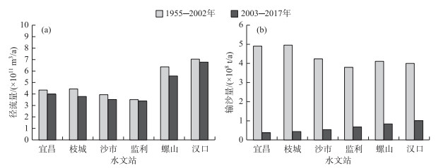
三峡工程蓄水运用后,2003—2017年与1955—2002年相比,宜昌、枝城、沙市、监利、螺山和汉口等水文站年均径流量分别减少6.54 %、14.46 %、10.41 %、4.28 %、12.56 % 和3.60 % (图 3a),年均输沙量则分别减少92.70 %、91.37 %、87.478 %、82.32 %、79.71 % 和74.80 % (图 3b),含沙量分别减少92.19 %、89.91 %、86.01 %、81.53 %、76.87 % 和73.86 %.
|
图 3 长江中下游径流量和输沙量 Fig.3 Runoff and sediment load of the middle and lower reaches of the Yangtze River |
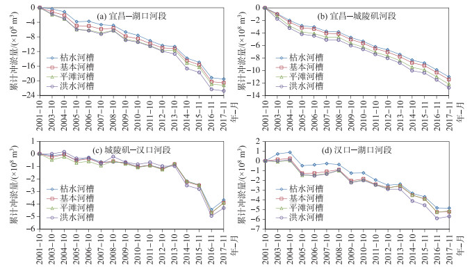
2002年10月-2017年11月期间,宜昌-湖口河段枯水河槽、基本河槽、平滩河槽及洪水河槽的冲刷量分别为19.54×10⁸、20.57×10⁸、21.24×10⁸和22.78×10⁸ m3(图 4a). 2002年10月—2017年11月期间,宜昌-城陵矶河段(408 km)、城陵矶-汉口河段(251 km)、汉口-湖口河段(295.4 km)枯水河槽冲刷量分别为11.01×10⁸、3.69×10⁸、4.85×10⁸ m3,冲刷强度为17.98×10⁴、9.18×10⁴和10.26×10⁴ m3/(km ·a);洪水河槽冲刷量分别为12.76×10⁸、4.23×10⁸、5.70×10⁸m3,冲刷强度为20.85×10⁴、10.76×10⁴和12.06×10⁴ m3/(km ·a) (图 4b~d). 从空间上看,三峡工程运行后近坝的宜昌-城陵矶河段冲刷强度较大,向下游逐渐减弱;主要原因为:近坝段受清水下泄的影响最为迅速,同时宜昌-监利河段沙质段河床补给较为充足,尤其是d > 0.125 mm粒径组的泥沙在监利站补给程度达到最大[36-38],即河床冲刷集中在宜昌-城陵矶河段. 从时间上看,三峡工程运行初期,近坝段的冲刷强度较大,集中在宜昌-城陵矶河段,自2012年以来城陵矶-汉口河段、汉口-湖口河段的冲刷强度呈增强态势.
|
图 4 三峡大坝下游河道冲淤量变化 Fig.4 Changes in the river scouring and siltation volumes of the downstream of the Three Gorges Dam |
2002—2017年期间,宜昌-湖口河段枯水河槽冲刷量占洪水河槽冲刷量的85.78 %,其中宜昌-城陵矶河段、城陵矶-汉口河段和汉口-湖口河段比例分别为86.36 %、85.31 % 和85.09 %;2002—2017年期间,宜昌-湖口河段平滩河槽冲刷量占洪水河槽冲刷量的93.24 %,其中宜昌-城陵矶河段、城陵矶-汉口河段和汉口-湖口河段比例分别为95.45 %、90.74 % 和90.18 % (表 1). 河床冲刷以枯水河槽为主,向下游枯水河槽冲刷比例略有减小,岸滩冲刷比例逐渐增加.
| 表 1 河道冲淤量及滩槽分布的关系 Tab. 1 Relationships between river scouring and siltation volumes and beach and channel distributions |
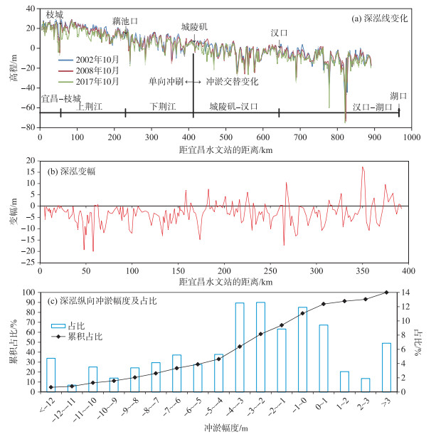
2017年11月与2002年10月比较(图 5),宜昌站下游0~166 km河段内的深泓为整体下切,166~392 km河段内冲淤交替变化,以冲刷为主. 宜昌-城陵矶河段深泓淤积长度占22.1 %,最大淤积厚度为17.4 m;宜昌-湖口河段内深泓冲刷的河道长度占河道总长度的78.9 %,最大冲深为19.98 m,且深泓冲深幅度集中在0~5 m之间,占宜昌-湖口河段总长度的51.18 %.
|
图 5 长江中游河道纵向深泓线变化(横轴负值为冲刷, 正值为淤积) Fig.5 Variations in the thalweg of the middle reaches of the Yangtze River |
2008年10月与2002年10月、2017年11月与2008年10月进行比较,宜昌-枝城河段平均下切2.43和2.11 m,上荆江河段平均下切0.79和2.47 m,下荆江河段平均下切0.81和1.54 m,城陵矶-汉口河段平均下切0.56和1.69 m,汉口-湖口河段平均下切-0.22 m(淤积)和2.33 m(表 2). 已有研究证实[36-38],三峡工程运行后长江中游宜昌-枝城段河床明显粗化,河床抗冲性增强,是该段河床冲刷强度减弱的原因之一.
| 表 2 长江中游河道深泓冲淤变化 Tab. 2 Changes in the scouring and silting processes of the middle reaches of the Yangtze River |
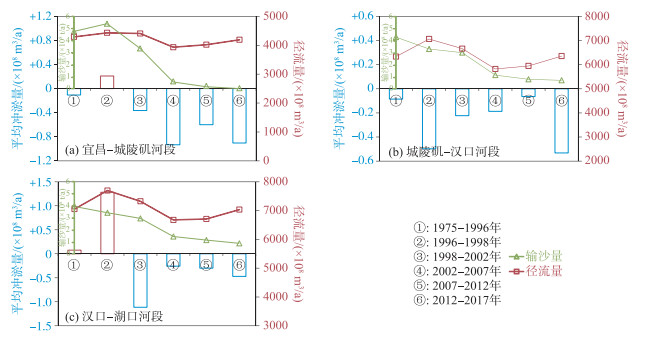
对1975—2017年长江中游河道的冲淤量及冲刷强度变化(图 6)进行分析表明:1) 宜昌-城陵矶河段. 三峡工程运行前1975—2002年河床冲淤交替变化,2002—2017年为冲刷趋势,年均冲刷强度显著高于三峡工程运行前的各时段. 2) 城陵矶-汉口河段. 三峡工程运行前、运行后河道均为冲刷态势,2012年以来河道冲刷强度增强. 1996—2012年4个时段,输沙量显著减少,水流次饱和程度增加,水流冲刷强度增加. 3) 汉口-湖口河段. 三峡工程运行前冲淤交替且幅度较大,运行后冲淤幅度呈增大趋势. 2003—2017年河道输沙量减少,径流量变化不大,引起水流次饱和程度增加,是河床冲刷强度增强的主控因素. 同时,汉口-湖口河段的河床组成为沙质,虽然河床存在一定的粗化态势,其表层的沙质覆盖层仍较厚[36-38],即河床冲刷强度仍存在进一步增强的态势.
|
图 6 平滩河槽冲淤强度与径流量和输沙量的关系(平均冲淤量的正值表示河床淤积,负值表示河床冲刷) Fig.6 Relationships between scouring and siltation intensity in flat beaches and river channels with runoff and sediment load |
本节重点分析分汊河型枯水期主汊分流比及江心洲面积、单一弯曲河段滩槽冲淤分布及边滩面积等变化,明确航道整治工程阶段性的影响及差异性.
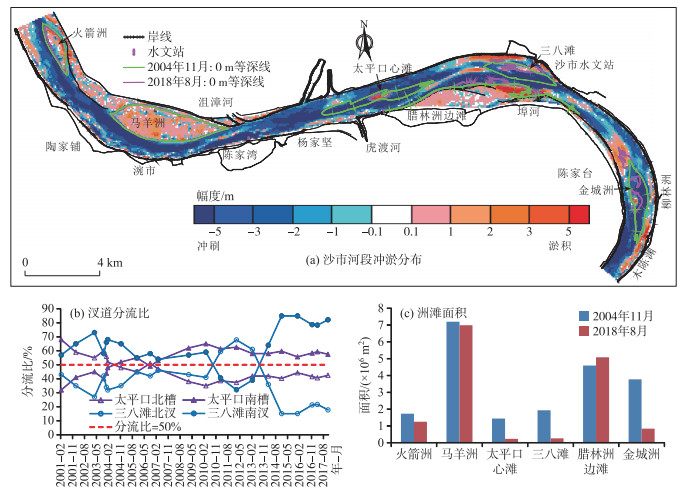
3.1 分汊河型冲淤特性变化以沙市河段为对象,分析近坝段沙质河床及多分汊河型的河床冲淤强度、汊道分流比及边心滩面积等变化. 沙市河段处于近坝段的沙质河床,河道形态为微弯分汊型,其河床的抗冲性较差[36-38]. 2004年11月—2018年8月期间,沙市河段河床显著冲刷,其枯水河槽、基本河槽、平滩河槽及洪水河槽冲刷量分别为2.09×10⁸、2.15×10⁸、2.21×10⁸和2.20×10⁸ m3;枯水河槽冲刷占总冲刷量的94.14 %,冲刷深度集中在3~5 m,仅在马羊洲、杨林矶边滩、腊林洲边滩及金城洲中部区域略有淤积(图 7a). 以2006、2013年为分界年份,太平口心滩、三八滩汊道在枯水期均发生了主汊和支汊交替现象(图 7b). 火箭洲、马羊洲、太平口心滩、三八滩和金城洲的面积减幅为27.75 %、2.92 %、83.68 %、86.42 % 和77.72 %,腊林洲边滩的面积淤涨10.68 % (图 7c).
|
图 7 长江中游典型分汊河段的河床冲淤变化 Fig.7 Changes in the riverbed scouring and siltation in typical branching streams of the middle reaches of the Yangtze River |
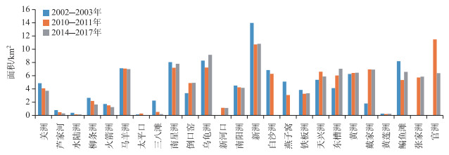
分汊河段的江心洲演变划分为4种类型(图 8):持续减小、先增大后减小、先减小后增大、持续增大. 面积持续减小的江心洲有关洲、芦家河、水陆洲、柳条洲、火箭洲、马羊洲、太平口心滩、三八滩及金城洲,其中火箭洲、马羊洲、太平口心滩为实施航道治理工程,受清水下泄影响面积为减少态势,关洲、芦家河、水陆洲、柳条洲、三八滩及金城洲的面积在航道工程实施后仍处于减少态势,航道整治工程稳定了滩槽格局,由于处于近坝段受清水下泄的影响最为直接且程度较大,其江心洲洲体及洲头低滩的面积仍为减小态势;面积先减小后增大的江心洲有南星洲、乌龟洲、新洲、铁板洲、鳊鱼滩、张家洲,这类洲体的规模相对较大,洲头的低滩范围有限,在航道整治工程的实施后面积为增加态势;面积先增大后减小的江心洲有天兴洲、戴家洲、官洲等,这类滩体在航道整治工程实施后面积为增大态势,但洲头低滩仍存在一定的冲刷,在航道水深提升中仍需要实施维持江心洲完整性的守护工程;面积持续增大的江心洲有倒口窑、东槽洲,这类洲体实施了连续的多期航道整治工程,工程效果得到了较好的发挥,江心洲面积为增大态势.
|
图 8 长江宜昌-湖口段江心洲面积变化 Fig.8 Changes in the area of the alluvial islands in the Yichang-Hukou section of the Yangtze River |
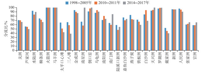
以枯水期主汊为对象(1998—2005年期间为枯水主汊),统计相近枯水流量条件下的主汊分流比变化(图 9). 分流比变化划分为4种类型:持续减小、先增大后减小、先减小后增大、持续增大. 枯水期主汊分流比持续减小的汊道主要有关洲、芦家河、柳条洲、太平口心滩、三八滩、金城洲、铁板洲和戴家洲等,其中关洲、芦家河、柳条洲所在分汊段江心洲持续冲刷,汊道进口水流摆动空间增加,主汊分流比有所减小;同时多分汊段的沙市河段(太平口心滩、三八滩)汊道分流受滩群演变、采砂活动、桥梁工程等影响,已发生了主汊和支汊交替变化;铁板洲和戴家洲汊道因航道整治工程实施中,考虑外部环境限制枯水期通航主汊道选择了通航环境相对较好的支汊(分流比在40 % ~50 % 之间),由于航道整治工程作用及功能的发挥,这类河段的枯水期主汊(1998—2005年期间的枯水期主汊)分流比为减少态势. 枯水期主汊分流比先增大后减小的汊道有乌龟洲与南阳洲,2010年以前监利河段右岸侧新河口边滩冲刷及乌龟洲右缘崩退,使得右汊分流比增大;随着河势控制及航道整治工程的实施,监利河段枯水期主汊和支汊分流关系基本稳定. 枯水期主汊分流先减小后增大的汊道有水陆洲、南星洲、南门洲、陆溪口新洲、嘉鱼白沙洲,这类汊道主要是由于航道整治工程的实施稳定了滩槽格局,随着工程效果的发挥,枯水期主汊分流比在工程后为增大态势. 枯水期分流比持续增大的汊道有倒口窑、天兴洲、罗湖洲、张家洲和官洲等,这类汊道在三峡工程运行后主要是洲滩形态不稳定,由于及时实施了航道整治工程,枯水期主汊分流比得到维持并有所增大.
|
图 9 长江宜昌-湖口段枯水期主汊分流比变化 Fig.9 Changes in the branching ratio in the Yichang-Hukou section of the Yangtze River in the dry season |
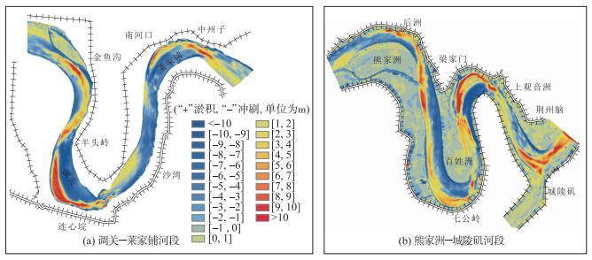
三峡工程运行前,长江中游弯曲河段演变特征为“凸岸边滩淤积,凹岸冲刷”[30]. 三峡工程运行后,中枯水流量天数增加,水流作用在凸岸侧滩地的天数增加. 在不饱和水流作用下,急弯段的调关-莱家铺、熊家洲-城陵矶表现为“凸岸边滩冲刷,凹岸侧深槽淤积”的特征(图 10).
|
图 10 长江中游典型弯曲河段的河床冲淤变化(2002—2013年)[31] Fig.10 Scouring and silting variations on the riverbed in typical curved sections of the middle reaches of the Yangtze River (2002-2013)[31] |
图 11为长江中游宜昌-湖口河段内的边滩面积变化,分析表明:腊林洲边滩、徐家湾边滩由于航道整治工程的实施,其面积为增大态势. 金城洲、牧鹅洲、赵家矶及牯牛沙等边滩的面积为减小态势,其中金城洲处于近坝段,受清水冲刷的影响程度大,航道整治工程稳定了边滩的位置,其面积仍为减小态势;牧鹅洲边滩面积略有减小,对赵家矶边滩受水流顶冲的掩护作用减弱,使得赵家矶边滩在航道整治工程实施后面积仍为一定程度的减小态势;牯牛沙边滩实施了两期的航道整治工程,整体形态位置较为稳定,面积仍维持减小态势,但凹岸侧主槽的航道水深相对较好. 七弓岭和七弓岭心滩处于急弯段,边滩发育的规模相对较小,近期的面积为减小态势. 人民洲边滩面积为先减小后增大,表明航道整治工程有效守护了边滩的形态.

|
图 11 长江中游宜昌至湖口河段内边滩面积变化 Fig.11 Changes in the areas of inner beaches in the Yichang-Hukou section of the middle reaches of the Yangtze River |
1) 三峡工程运行后,2003—2017年期间长江中游河道发生了累积性冲刷,其中枯水河槽冲刷量占总冲刷量的85.78 %;砂卵石河段冲刷强度先增强后减弱,河床冲刷进程逐渐向下游沙质河段推进,目前强冲刷区域已达距坝约400 km,其下游的河道冲刷强度仍呈持续增强态势.
2) 三峡工程运行以来,长江中游分汊河段江心洲以冲刷为主,上荆江河段内实施的航道整治工程稳定了江心洲形态,但面积受清水下泄的影响为减少态势,枯水期主汊分流比为减少态势,部分汊道发生了主支汊交替变化;下荆江及下游分汊河段江心洲面积虽然交替变化,整体上航道整治工程有效控制了江心洲规模. 弯曲河段凸岸侧边滩以冲刷为主,急弯段的凹岸侧深槽淤积,微弯段凸岸边滩冲刷,凹岸侧深槽相对稳定.
| [1] |
Dang MH, Umeda S, Yuhi M. Long-term riverbed response of lower Tedori River, Japan, to sediment extraction and dam construction. Environmental Earth Sciences, 2014, 72(8): 2971-2983. DOI:10.1007/s12665-014-3202-0 |
| [2] |
Rinaldi M, Simon A. Bed-level adjustments in the Arno River, central Italy. Geomorphology, 1998, 22(1): 57-71. DOI:10.1016/S0169-555X(97)00054-8 |
| [3] |
Yang YP, Zhang MJ, Zhu LL et al. Influence of large reservoir operation on water-levels and flows in reaches below dam: Case study of the Three Gorges Reservoir. Scientific Reports, 2017, 7: 15640. DOI:10.1038/s41598-017-15677-y |
| [4] |
Yang YP, Zhang MJ, Sun ZH et al. The relationship between water level change and river channel geometry adjustment in the downstream of the Three Gorges Dam (TGD). Acta Geographica Sinica, 2017, 72(5): 776-789. [杨云平, 张明进, 孙昭华等. 三峡大坝下游水位变化与河道形态调整关系研究. 地理学报, 2017, 72(5): 776-789.] |
| [5] |
Yang YP, Zhang MJ, Sun ZH et al. Characteristics and reason of riverbed evolution difference in the middle Yangtze River based on river unit model. Journal of Basic Science and Engineering, 2018, 26(1): 70-84. [杨云平, 张明进, 孙昭华等. 基于河段单元尺度长江中游河床形态调整过程及差异性研究. 应用基础与工程科学学报, 2018, 26(1): 70-84.] |
| [6] |
Hoyle J, Brooks A, Brierley G et al. Spatial variability in the timing, nature and extent of channel response to typical human disturbance along the upper Hunter River, New South Wales, Australia. Earth Surface Processes and Landforms, 2008, 33(6): 868-889. DOI:10.1002/esp.1580 |
| [7] |
Wang S, Fu BJ, Piao SL et al. Reduced sediment transport in the Yellow River due to anthropogenic changes. Nature Geoscience, 2016, 9(1): 38-41. DOI:10.1038/ngeo2602 |
| [8] |
Nittrouer JA, Viparelli E. Sand as a stable and sustainable resource for nourishing the Mississippi River delta. Nature Geoscience, 2014, 7(5): 350-354. DOI:10.1038/ngeo2142 |
| [9] |
Pinter N, Heine RA. Hydrodynamic and morphodynamic response to river engineering documented by fixed-discharge analysis, lower Missouri River, USA. Journal of Hydrology, 2005, 302(1/2/3/4): 70-91. DOI:10.1016/j.jhydrol.2004.06.039 |
| [10] |
Stevaux JC, Martins DP, Meurer M. Changes in a large regulated tropical river: The Paraná River downstream from the Porto Primavera Dam, Brazil. Geomorphology, 2009, 113(3/4): 230-238. DOI:10.1016/j.geomorph.2009.03.015 |
| [11] |
Zheng SR. Reflections on the Three Gorges project since its operation. Engineering, 2016, 2(4): 389-397. DOI:10.1016/J.ENG.2016.04.002 |
| [12] |
Hu CH, Fang CM. Research on sediment problem solutions for the Three Gorges Project and it operational effects. Scientia Sinica: Technologica, 2017, 47(8): 832-844. [胡春宏, 方春明. 三峡工程泥沙问题解决途径与运行效果研究. 中国科学: 技术科学, 2017, 47(8): 832-844. DOI:10.1360/N092017-00098] |
| [13] |
Lai X, Yin D, Finlayson BL et al. Will river erosion below the Three Gorges Dam stop in the middle Yangtze?. Journal of Hydrology, 2017, 554: 24-31. DOI:10.1016/j.jhydrol.2017.08.057 |
| [14] |
Chai YF, Zhu BY, Yue Y et al. Reasons for the homogenization of the seasonal discharges in the Yangtze River. Hydrology Research, 2020, 51(3): 470-483. DOI:10.2166/nh.2020.143 |
| [15] |
Xu QX, Zhu LL, Yuan J. Research on water-sediment variation and deposition-erosion in middle and lower Yangtze River. Yangtze River, 2013, 44(23): 16-21. [许全喜, 朱玲玲, 袁晶. 长江中下游水沙与河床冲淤变化特性研究. 人民长江, 2013, 44(23): 16-21. DOI:10.3969/j.issn.1001-4179.2013.23.004] |
| [16] |
Xu QX. Research on reservoir sedimentation and downstream channel erosion of dam after impoundment of Three Gorges Reservoir. Yangtze River, 2012, 43(7): 1-6. [许全喜. 三峡水库蓄水以来水库淤积和坝下冲刷研究. 人民长江, 2012, 43(7): 1-6. DOI:10.3969/j.issn.1001-4179.2012.07.001] |
| [17] |
Xu QX. Study of sediment deposition and erosion patterns in the middle and downstream Changjiang mainstream after impoundment of TGR. Journal of Hydroelectric Engineering, 2013, 32(2): 146-154. [许全喜. 三峡工程蓄水运用前后长江中下游干流河道冲淤规律研究. 水力发电学报, 2013, 32(2): 146-154.] |
| [18] |
Dai ZJ, Liu JT, Wei W et al. Detection of the Three Gorges Dam influence on the Changjiang (Yangtze River) submerged delta. Scientific Reports, 2014, 4: 6600. DOI:10.1038/srep06600 |
| [19] |
Lyu YW, Fagherazzi S, Tan GM et al. Hydrodynamic and geomorphic adjustments of channel bars in the Yichang-Chenglingji Reach of the middle Yangtze River in response to the Three Gorges Dam operation. CATENA, 2020, 193: 104628. DOI:10.1016/j.catena.2020.104628 |
| [20] |
Xia JQ, Deng SS, Zhou MR et al. Geomorphic response of the Jingjiang Reach to the Three Gorges Project operation. Earth Surface Processes and Landforms, 2017, 42(6): 866-876. DOI:10.1002/esp.4043 |
| [21] |
Deng SS, Xia JQ, Zhou MR et al. Coupled modeling of bed deformation and bank erosion in the Jingjiang Reach of the middle Yangtze River. Journal of Hydrology, 2019, 568: 221-233. DOI:10.1016/j.jhydrol.2018.10.065 |
| [22] |
Huang XL, Wang WK, Zhu MH et al. "2016.7" Flood dike risk analysis and enlightenment in the middle and lower reaches of the Yangtze River. China Flood & Drought Management, 2016, 26(5): 47-49. [黄先龙, 王文科, 褚明华等. "2016.7"长江中下游洪水干堤险情分析及启示. 中国防汛抗旱, 2016, 26(5): 47-49. DOI:10.3969/j.issn.1673-9264.2016.05.019] |
| [23] |
Zhang W, Yang YP, Zhang MJ et al. Mechanisms of suspended sediment restoration and bed level compensation in downstream reaches of the Three Gorges Projects (TGP). Journal of Geographical Sciences, 2017, 27(4): 463-480. DOI:10.1007/s11442-017-1387-3 |
| [24] |
Sun ZH, Li YT, Ge H et al. Channel erosion processes of transitional reach from gravel river bed to sand bed in middle Yangtze River. Journal of Hydraulic Engineering, 2011, 42(7): 789-797. [孙昭华, 李义天, 葛华等. 长江中游沙卵石-沙质河床过渡带冲刷趋势研究. 水利学报, 2011, 42(7): 789-797.] |
| [25] |
Han JQ, Sun ZH, Huang Y et al. Features and causes of sediment deposition and erosion in Jingjiang reach after impoundment of the Three Gorges Project. Journal of Hydraulic Engineering, 2014, 45(3): 277-285, 295. [韩剑桥, 孙昭华, 黄颖等. 三峡水库蓄水后荆江沙质河段冲淤分布特征及成因. 水利学报, 2014, 45(3): 277-285, 295.] |
| [26] |
Yang YP, Zhang MJ, Liu WL et al. Relationship between waterway depth and low-flow water levels in reaches below the Three Gorges Dam. Journal of Waterway, Port, Coastal, and Ocean Engineering, 2019, 145(1): 04018032. DOI:10.1061/(asce)ww.1943-5460.0000482 |
| [27] |
You XY, Zhang XF, Wan W et al. Mutability and periodicity of the characteristic flow level of bifurcated reaches in the middle reaches of the Yangtze River. Journal of Hydrologic Engineering, 2020, 25(9): 05020027. DOI:10.1061/(asce)he.1943-5584.0001985 |
| [28] |
Liu Y, Yao SM, Xie Y et al. Mode and domination of major-minor alternation for anabranching bends. Journal of Basic Science and Engineering, 2020, 28(1): 18-26. [刘亚, 姚仕明, 谢炎等. 弯曲分汊河型主支汊交替模式及驱动机制研究. 应用基础与工程科学学报, 2020, 28(1): 18-26.] |
| [29] |
Zhao WY, Yang YP, Zhang HQ et al. Adjustment patterns and causes of the morphology of sandy riverbed downstream of the Three Gorges Dam. Advances in Water Science, 2020, 31(6): 862-874. [赵维阳, 杨云平, 张华庆等. 三峡大坝下游近坝段沙质河床形态调整及洲滩联动演变关系. 水科学进展, 2020, 31(6): 862-874.] |
| [30] |
Zhu LL, Xu QX, Chen ZH. Extraordinary scour of Jingjiang reach downstream from Three Gorges Project. Journal of Basic Science and Engineering, 2018, 26(1): 85-97. [朱玲玲, 许全喜, 陈子寒. 新水沙条件下荆江河段强冲刷响应研究. 应用基础与工程科学学报, 2018, 26(1): 85-97.] |
| [31] |
Zhu LL, Xu QX, Xiong M. Fluvial processes of meandering channels in the Lower Jingjiang River reach after the impoundment of Three Gorges Reservior. Advances in Water Science, 2017, 28(2): 193-202. [朱玲玲, 许全喜, 熊明. 三峡水库蓄水后下荆江急弯河道凸冲凹淤成因. 水科学进展, 2017, 28(2): 193-202.] |
| [32] |
Yang SL, Xu KH, Milliman JD et al. Decline of Yangtze River water and sediment discharge: Impact from natural and anthropogenic changes. Scientific Reports, 2015, 5: 12581. DOI:10.1038/srep12581 |
| [33] |
Chai YF, Li YT, Yang YP et al. Influence of climate variability and reservoir operation on streamflow in the Yangtze River. Scientific Reports, 2019, 9: 5060. DOI:10.1038/s41598-019-41583-6 |
| [34] |
Zhu LL, Dong XY, Chen ZF. Sediment deposition of cascade reservoirs in the lower Jinsha River and its impact on Three Gorges Reservoir. Journal of Yangtze River Scientific Research Institute, 2017, 34(3): 1-7. [朱玲玲, 董先勇, 陈泽方. 金沙江下游梯级水库淤积及其对三峡水库影响研究. 长江科学院院报, 2017, 34(3): 1-7.] |
| [35] |
Zhou YJ, Li DF, Lu JY et al. Distinguishing the multiple controls on the decreased sediment flux in the Jialing River basin of the Yangtze River, Southwestern China. CATENA, 2020, 193: 104593. DOI:10.1016/j.catena.2020.104593 |
| [36] |
Yang YP, Zhang MJ, Li SZ et al. Transport patterns of the coarse and fine sediments and its causes in the downstream of the Three Gorges Dam. J Lake Sci, 2017, 29(4): 942-954. [杨云平, 张明进, 李松喆等. 三峡大坝下游粗细颗粒泥沙输移规律及成因. 湖泊科学, 2017, 29(4): 942-954. DOI:10.18307/2017.0418] |
| [37] |
Guo XH, Qu G, Liu Y et al. Sediment transport of different particle size groups in the downstream channel after operation of the Three Gorges Project. J Lake Sci, 2020, 32(2): 564-572. [郭小虎, 渠庚, 刘亚等. 三峡工程运用后坝下游河道泥沙输移变化规律. 湖泊科学, 2020, 32(2): 564-572. DOI:10.18307/2020.0226] |
| [38] |
Li SZ, Yang YP, Zhang MJ et al. Coarse and fine sediment transportation patterns and causes downstream of the Three Gorges Dam. Frontiers of Earth Science, 2018, 12(4): 750-764. DOI:10.1007/s11707-017-0670-z |
 2021, Vol. 33

